
Yukon Volcanism
Experience Yukon's stunning volcanic landscapes
Overview
Distribution of volcanic rocks in the Yukon. Modified from the Yukon Bedrock Geology Map; Yukon Geological Survey 2023.
The Yukon has a long history of volcanic activity. The oldest volcanic rocks are ~ 1.6 billion years old, found in the Wernecke breccias north of Dawson City and in the Peel Plateau ( 1 ) . The youngest volcanic rocks, which erupted from Yukon's only "active" volcano, are less than 10,000 years old and can be found near Fort Selkirk, west of Carmacks in south-central Yukon ( 1 ) . Volcanic rocks found across the Yukon vary greatly in age and have fascinating formation histories. For example, some deposits originated as flood basalts on an ocean floor, while others are the result of crustal thinning due to continental rifting.
This virtual field experience focuses on volcanic rocks that are part of the Northern Cordilleran Volcanic Province (formerly the Stikine Volcanic Belt), which extends from southern British Columbia, through the Yukon, and into eastern Alaska. This province hosts more than 100 volcanic centres that erupted from 20 million years ago until as recently as 200 years ago ( 1 ) ! The volcanic centres represent a wide range of eruption styles, from small single-eruption flows to expansive multi-flow plateaus.
Approximate area of the Northern Cordilleran Volcanic Province. Modified from Edwards and Russell (1999).
This volcanic belt was created from tectonic activity related to the formation of the Cordilleran mountain ranges. In Canada, the subduction of oceanic crust and the accretion of allochthonous (exotic) terranes ( 1 ) approximately 185 million years ago spurred the formation of the Cordillera. During this period of tectonism, the crust experienced transpression, a combination of compression and lateral movement, resulting in complexly deformed rocks and mountain uplift. After ~ 45 million years of transpression, the region transitioned to a transtensional regime, a combination of extension and lateral movement, which led to thinning of the crust. Lateral movement along faults created local zones of crustal weakness. Magma generated in the Earth's mantle rose buoyantly through these zones of weakness and erupted on surface, resulting in the volcanic features we see today. This transtensional tectonic phase with associated volcanism is responsible for creating the Northern Cordilleran Volcanic Province ( 1 ) .
Yukon University's Dr. Joel Cubley discusses the causes of young volcanic activity in the Yukon.
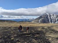
Virtual Experience Field Sites
This Virtual Geology field experience will focus on eruptive centers in the Yukon that are part of the Northern Cordilleran volcanic province. The virtual field sites highlighted include:
- Alligator Lake volcanic complex - which hosts world-class examples of volcanic features such as columnar basalt rosettes, volcanic ejecta, samples from the Earth's mantle, and more!
- Fort Selkirk volcanic field - which is home to at least seven volcanic centers along the Yukon River, including evidence of a sub-glacial eruption and Yukon's youngest volcano.
Select a field site below to begin your exploration of volcanism in the Yukon. If you want to learn more about igneous rocks and volcanology, continue to scroll past the interactive map for additional information.
Alligator Lake volcanic complex
Alligator Lake volcanic complex. Click to expand.
Two cinder cones and a lava flow plateau located ~40 km southwest of Whitehorse.
Fort Selkirk volcanic field (FSVF)
Fort Selkirk volcanic field (FSVF) . Click to expand.
Visit three areas of volcanic activity in the FSVF: Volcano Mountain, Ne Ch'e Ddhäwa, and Yukon River volcanic exposures.
Alligator Lake volcanic complex
Two cinder cones and a lava flow plateau located ~40 km southwest of Whitehorse.
Fort Selkirk volcanic field (FSVF)
Visit three areas of volcanic activity in the FSVF: Volcano Mountain, Ne Ch'e Ddhäwa, and Yukon River volcanic exposures.
What are igneous rocks?
An igneous rock (from Latin ignis, meaning "fire") is a rock that is produced from the cooling and solidification of hot, molten rock. Igneous rocks are very common, making up 95% of the Earth's crust.
Igneous rocks vary compositionally and depending on the minerals present in the rock, they are broadly classified into one of the following categories:
- Felsic: light coloured, composed dominantly of feldspar-silicate minerals
- Intermediate: a sub-equal combination of both mafic and felsic minerals
- Mafic: dark coloured, composed dominantly of magnesian-ferric minerals
There are two main genetic categories of igneous rocks that are used to describe where the magma cooled and crystallized. These two groups are intrusive and extrusive.
Granodiorite is a great example of an intrusive, phaneritic igneous rock. This sample was collected from the Grafter Extension Outcrop in the Whitehorse Copper Belt.
Intrusive rocks form when magma cools and solidifies under the Earth's surface. In this environment, the surrounding rocks act as insulation, resulting in slow conductive cooling of the magma body. This allows the crystallizing minerals to have a long time to grow, resulting in textures characterized by coarse mineral grains. The proper term for this texture is phaneritic, meaning one can see individual mineral grains with the unaided eye. Intrusive igneous rock bodies are called plutons.
This palagonite tuff a great example of an extrusive, aphanitic, igneous rock. This sample was collected from Ne Ch'e Ddhäwa in the Fort Selkirk volcanic field.
Extrusive rocks form when magma reaches the Earth's surface at an eruptive centre; once on surface it is referred to as lava. Lava cools and solidifies rapidly on the Earth's surface. The rapid cooling shortens mineral crystal growth time, resulting in textures characterized by fine minerals grains. The proper term for this texture is aphanitic, meaning one cannot see individual mineral grains with the unaided eye. Extrusive rocks, commonly called volcanic rocks, are associated with many different styles of eruption and eruptive locations on Earth's surface.
Volcanology 101
Volcanology is the study of all aspects of volcanism, and there are many sub-disciplines. For example, physical volcanologists study the eruption process and related deposits; geochemists study the composition of the lava, gases, and volcanics; geophysicists study seismic activity which is important in volcanic monitoring and early warning systems; and remote sensing specialists use electronic equipment and modelling software to monitor and predict the timing and severity of a potential eruption. All of these sub-disciplines are important in order to fully understand the mechanisms, intricacies, and risks associated with volcanism.
Parts of a volcano
This illustration is a schematic of the parts of a volcano.
- Volcanic edifice: the landform that is built by layers of lava and pyroclastic material
- Magma chamber: the magma source in the Earth's crust that ascended upwards from the mantle
- Conduit: the channel or passage that allows magma from the magma chamber to travel up to the vent
- Vent: the opening in the Earth's crust from which lava, pyroclastic material, and gases are erupted
- Crater: a bowl-shaped depression that surrounds the vent at the top of the edifice
- Flank: the side of the volcano
Volcanic Landforms
Volcanoes are classified into three main categories, each with typical characteristics, such as viscosity (resistance to flow) of the magma, amount of dissolved gas, magma composition, tectonic setting, and eruption style.
The three main types of volcanoes are shield volcanoes, stratovolcanoes, and cinder cones. Depending on the style of eruption, other landforms such as lava domes, fissure vents, and calderas can arise from erupting magma.
Shield volcanoes are the largest type of volcano, with broad, gentle slopes that dip less than 10°. The flat surface is thought to resemble a warrior's shield. An excellent example is Mauna Loa on Hawai'i Island. It is Earth's largest volcano, with a diameter of 200 km and a height of 4169 m above sea level (a.s.l.)!
These volcanoes get their gentle hill-like shape from consecutive lava flows of low-viscosity basaltic lava. The lava spreads over large areas and cools in thin, dipping sheets, making an expansive, gradually sloping lava flow. Lava usually erupts from a central vent but can also erupt from smaller vents on the flanks.
This simple illustration depicts the general shape of a shield volcano. This illustration is not drawn to the same scale as the following volcanoes.
Stratovolcanoes, also called composite volcanoes, are the next largest volcano type. A famous example is Mount Fuji in Japan, with a diameter of 45 km and reaching 3776 m a.s.l.!
Stratovolcanoes are conical in shape, with steep-sloping sides at roughly 30-35° and a prominent summit. This classic volcano shape is formed from alternating layers of lava flow and tephra (accumulation of ejected pyroclastic material). The most recent tephra deposit piled at the crater causes the slope to steepen near the volcano's summit. Atop most stratovolcanoes lie a large crater with a central vent or a group of vents. Lava erupts through the central vent or from fissures vents on the cone's flanks.
This simple illustration depicts the general shape of a stratovolcano. This illustration is not drawn to the same scale as the other two volcanoes.
Cinder cones, also called spatter or scoria cones, are the smallest volcanic cones. They are typically less than 200 m high and have relatively steep sides. For example, Eve Cone in British Columbia has a diameter of less than 500 m and rises 172 m above the surrounding terrain.
Cinder cones form from gas-rich lava, commonly producing vesicular basalt and scoria rocks. Lava gets propelled violently into the air from a single vent and the pyroclastic debris falls back down to the Earth's surface, building the cone shape. The edifice is built from the fall back of loose, unconsolidated material. This typically causes cinder cones to have little strength and they are susceptible to erosion or crater collapse.
This simple illustration depicts the general shape of a shield volcano. This illustration is not drawn to the same scale as the previous two volcanoes.
This illustration shows the relative sizes of a shield volcanoes, stratovolcanoes, and cinder cones! The sizes of these volcano types differ by orders of magnitude.
Stages of a volcano's life
The three main stages of a volcano are active, dormant, or extinct. There are many inconsistencies and contradictory definitions when categorizing volcanoes. It is important to remember that there is not a single definition of these terms that is agreed upon amongst volcanologists, but here is a general summary:
- Active: A volcano that erupts on a regular basis or that has erupted during the current geologic epoch, the Holocene (i.e., in the last 10 000 years). This classification does not imply that the volcano is currently erupting, but rather that the magma source is young and still active.
- Dormant or "potentially active": A volcano that is not currently erupting and has not erupted in the last 10 000 years, but has the potential to erupt again in the future.
- Extinct: A volcano that has no written record of an eruption, there is no sign of activity, and/or it is cut off from the magma supply.
It is possible for a volcano that is classified as extinct to have an unexpected (and often catastrophic) eruption. A few examples of this scenario includes the volcanoes of Yellowstone, Toba, and Vesuvius. All three of these now-active volcanoes were thought to be extinct before their infamous eruptions.
Basalt basics
This vesicular basalt with olivine phenocrysts was collected from the Alligator Lake volcanic complex.
Basalt is a mafic, aphanitic, extrusive igneous rock that is composed primarily of the minerals plagioclase, pyroxene, and olivine. This rock forms when basaltic magma erupts onto the surface as lava, cooling and crystallizing these minerals rapidly. Basalt is the most common volcanic rock on Earth, covering most of the ocean floor!
What are vesicles?
Some magmas have a large volume of gas dissolved in the molten rock. When the magma erupts as lava on the Earth’s surface, the dissolved gas tries to exsolve (escape) out of the lava. The outer surface of the lava cools and crystallizes rapidly, forming a crust which prevents the gas from exsolving and forces it to stay trapped in the lava. The lava solidifies, creating a network of rock around the trapped gas bubbles called vesicles. Two common types of rocks that have vesicles are scoria and vesicular basalt.
Scoria is a dark-coloured, mafic extrusive rock containing up to 90% vesicles. The remaining 10% of the rock consists of thin walls that surround the vesicles, comprised of microcrystalline glass and very fine grained crystallites. When there is a massive buildup of gas pressure in the magma chamber, the magma is said to be “supercharged” with gas. When the magma breaks through to the Earth’s surface, it creates a frothy lava that violently explodes from the volcano – similar to CO 2 being released after you open a shaken pop bottle. This frothy lava cools while in the air, falling to the ground as solidified scoria. If the magma is felsic in composition instead of mafic, the rock produced is pumice!
Vesicular basalt is also a dark-coloured, mafic extrusive rocks that contain vesicles. Scoria and vesicular basalt have the same chemical composition, so how do we distinguish them? Scoria has up to 90% vesicles, while basalt has a much lower proportion of vesicles. If there is a lower volume of dissolved gas in the lava, the resulting rock is vesicular basalt. If there is a high volume of gas dissolved in the lava, the resulting rock is scoria.
rock volume > vesicle volume = vesicular basalt
vesicle volume > rock volume = scoria
These images provide a comparison of vesicular basalt and scoria. The first photo (left) is vesicular basalt, with lots of solid rock between the vesicles. The proportion of solid rock is greater than vesicle volume. The second photo (right) is scoria, with a high vesicle density and little solid rock between vesicles. The proportion of vesicles is greater than solid rock.
Eruption styles
There are two main types of eruptions:
This scale shows the styles of eruption, ranging from effusive to explosive. Use this scale as a reference to the illustration below to see what these eruption styles look like.
- Effusive, when lava flows are the predominant expulsion. Lava flows are outpourings of molten rock onto Earth's surface. Depending on the composition of the lava, these flows have the ability to travel great distances from their vent.
- Explosive, when ejected pyroclastic material is the predominant expulsion. Fragments ejected during explosive eruptions are termed pyroclasts (from Greek meaning “fire-broken”). A pyroclast can be ejected volcanic material, or may be solid pieces of pre-existing rock that were broken off during the eruption. The term pyroclastic material is used to describe all types of pyroclasts, which are subdivided by size.
This illustration demonstrates the varying types of eruptions and the typically associated volcanic landform. Note: these illustrations are demonstrative only, and are not drawn to scale relative to one another.
Volcanic ejecta
Depending on the size of the particles, pyroclastic material falls into four main categories:
Ash is a mixture of broken glass, crystals, and lithic fragments that are < 2 mm in size.
During an explosive eruption, volcanic ash, water vapour, and hot gases form a dark, columnar pyroclastic cloud that rises out of the vent. This hot cloud of pyroclastic debris can travel very far distances due to its low density. When the ash falls to the ground, it creates thick dust-like layer that coats every surface it lands on. It can travel even further when carried by winds, causing major problems for air travel services and air quality. A recent example is the Eyjafjallajökull eruption in April 2010 in Iceland. Approximately 100 000 flights were cancelled all over Europe over a period of a week until the ash settled.
This photo is a sample of the White River Ash deposit, collected near Carmacks, YT. This tephra deposit has been documented over 7000 km away from its' source near the Yukon-Alaska border!
Lapilli (from Latin word lapillus, meaning "little stones") are spheroid, teardrop-shaped droplets of molten or semi-molten lava that were ejected from a volcanic eruption. They range in size from 2 to 64 mm.
These little blobs of molten rock will begin to solidify as they travel through the air. If the lapilli are still semi-molten when they land, the spheroid shape may flatten out instead of remaining ellipsoidal. As the lapilli continue to fall back to surface, the unconsolidated pile of these little fragments contribute to building the volcanic edifice.
This is a pile of lapilli from the Alligator Lake volcanic complex. Each individual lapillus was a little blob of lava. As the cinder cone continued to erupt, these lapilli piled up, layer by layer, building the cinder cone edifice!
Blocks are solid pieces of rock > 64 mm in diameter that get ejected into the air during an eruption. Their angular or sub-angular shapes and sharp edges suggest that they erupted during a very violent volcanic eruption as solid, broken fragments.
The type of rock that makes up a volcanic block differs widely depending on the type of volcano, the lava composition, and the rock on which the volcano formed atop. Blocks may be from old magma tunnels, hardened lava from previous eruptions, sections of the wall from the central vent, or even country rock beneath the volcano.
This is a photo of a volcanic block from the Alligator Lake volcanic complex. This solid fragment of rock was ejected into the air during an eruption, crumbling to pieces when it landed back on the surface with great force.
Bombs are partially or completely molten ellipsoids of lava that are > 64 mm in size. When they are erupted, they are still fluid and are susceptible to changing shape during flight. Some solidify completely while they are in the air, while others may remain partially molten when they land on surface.
Bombs are named according to their shapes and characteristics. Geologists who study morphology of volcanic bombs are able to determine the viscosity of the lava, velocity of flight, distance of ejection, rate of cooling, and deformation caused by impact.
Here is an excellent example of a spheroidal volcanic bomb from the Alligator Lake volcanic complex. While flying through the air, the surface tension of the moderately-fluid lava pulled the bomb into a nicely rounded shape.
Features of Flows
If the eruptive style of the volcano is more effusive, it typically produces lava flows. A lava flow is a stream of molten lava that is erupted from the volcanic vent. The speed at which the lava flow advances depends on a few factors, including the rate at which the lava erupts from the vent, the topography of the landscape over which the lava is flowing, and the viscosity of the lava.
Common lava flow textures
Pahoehoe (pronounced 'paw hoey hoey', meaning “smooth, unbroken lava” in Hawai'ian) lava flows occur when the viscosity is low and the eruption rate is slow. They commonly travel only a short distance from the vent.
These low viscosity lava flows produce thin sheets of lava around 1 - 3 m thick. It typically shows smooth or ropey texture on the top surface, resembling the look of a wrinkled tablecloth. Pahoehoe flows may advance as massive sheets of lava, or flow through lava channels and tubes. After the surface of the flow cools, the lava may break out and form a new lava flow lobe if the eruption rate is high enough to break through the solidified outer crust.
This is an excellent example of pahoehoe texture! This basalt sample was collected from Pillow Point along the Yukon River in the Fort Selkirk volcanic field.
'A'ā (pronounced 'ah ah', meaning “stony rough lava” in Hawai'ian) lava flows occur when the viscosity is slightly higher than pahoehoe flows, the eruption rate is high. These flows can travel greater distances from the vent.
These higher viscosity flows produce thicker lava sheets, around 3 - 20 m thick. The surface of an 'a'ā lava flow is sharp, rough, jagged, and irregular. The rough texture forms because the flow rate is too fast for the lava to flow plastically like pahoehoe, which causes the top surface of the flow to rapidly cool in irregular shaped fragments.
This sample of basalt has 'a'ā texture. It was collected from the southwest flows of Volcano Mountain (Nelruna) in the Fort Selkirk volcanic field.
Naturally geometric
Have you ever noticed a hexagonal shape in nature - perhaps in a dried-out mud puddle, or maybe the shape of a honeycomb? That's because hexagons are the most efficient shape when trying to minimize the perimeter for a given area. In other words, it's the most surface area inside the shape for the smallest total length on the edges. This is the easiest shape for natural phenomena to release stress, distribute surface tension, or arrange molecules. Hexagons are the most mechanically stable shape, as forces acting on all sides are equal, dispersing energy or stress equally around all 6 sides of the shape.
How does this relate to rocks? A common feature related to lava flows is columnar jointing. This phenomenon can be seen in lava flow examples all over the world, including Giant's Causeway in Ireland, the young basaltic flows of Iceland, Devil's Tower Monument in Wyoming, USA, or even right here in Whitehorse, Yukon!
Check out this 3D model of a segment of columnar basalt!
How do these naturally geometric columns form? When a large-volume lava flow erupts onto the Earth's surface, the top surface that is exposed to the air and the bottom surface that is in contact with the ground both start to cool. This decrease in temperature causes the lava to contract and shrink, which increases the surface tension on these outer surfaces of the lava flow. To allow the lava flow to become physically stable, big cracks called tension joints begin to form, which release the surface tension. What angle do these tension joints intersect at? You guessed it - 120°! As the lava flow continues to cool, the temperature gradient starts to migrate deeper into the flow, which enables these hexagonal cracks to propagate from the edges towards the center of the lava flow.
This illustration shows the process of the formation of straight columnar joints in a basalt flow.
This illustration shows the textures seen in a typical columnar basalt exposure.
The resulting rocks are straight, regular, parallel columns of basalt. This type of basalt column occurrence is called colonnade. Another texture of basalt columns is called entablature. This texture is recognized by chaotic orientations of columns that vary in size and orientation. This texture forms when meteoric water (rain) infiltrates down the tension joints between the upper colonnade columns and disrupts the hot lava in the core of the flow. The addition of cold water to this system changes the temperature cooling gradient from being parallel to the ground, to being chaotic and unpredictable. Since the formation of columns is perpendicular to the cooling gradient, the resulting columns are also chaotic and unpredictable in orientation.
Miles Canyon columnar basalts
A great, easily accessible example of basalt columns is in Miles Canyon, just 10 km south of Whitehorse, YT. At this location, the Yukon River has been eroding away the basalt columns for thousands of years. This erosion has been cutting the canyon deeper and deeper, exposing beautiful columnar basalt cliffs!
Secondary minerals in volcanic rocks
Just as volcanic edifices can change over time, so can the rocks that erupted! A common example of this is amygdaloidal texture. After a vesicular rock cools and crystallizes completely, the vesicles create a network of open pore space that water and other fluids can flow through. Over time, water that is rich in dissolved mineral constituents percolates through this pore network and slowly precipitates minerals into the cavities of the vesicles. These secondary minerals are often hydrothermal minerals, including quartz, calcite, or zeolite minerals. These mineral-filled vesicles are called amygdules, and a rock that has experienced this process can be described as amygdaloidal.
The amygdules may be mistaken for phenocrysts, which are primary igneous minerals that crystallized in the magma. A good method of decifering a phenocryst from an amygdule is to look at the shape of the mineral. Phenocrysts are typically angular and may be elongated, while amygdules are rounded, since they take the shape of the pre-existing vesicle/air bubble.
Here is an example of amygdaloidal basalt from Miles Canyon! There are some empty holes that are vesicles which have not been filled by secondary minerals. The white and cream-coloured blobs are the amygdules. After this basalt rock erupted and cooled on the surface, the vesicles were later filled in with calcite that precipitated out of groundwater that percolated through the rock.


