NIMPE, Viet Nam (2018)
Strengthening the management and use of geospatial data and technologies to support the implementation of Circular 54
The geographic dimension of Circular 54
Circular 54/2015/TT-BYT, released in December 2015, provides guidance on the mechanism for notification, reporting, and declaration of communicable diseases.
Under the circumstances described in the circular, different health care providers have the responsibility to immediately report suspected cases for 42 communicable diseases upon detection.
Such reporting takes place through the use of different forms that include information about the place of residence of the patient, the place of occurrence of an outbreak, or the geographic extent for which aggregated data that is being reported.
The National Institute of Malariology, Parasitology, and Entomology (NIMPE) has then the responsibility to conduct inspections as well as monitor and evaluate the reporting and notification of communicable diseases and outbreaks.
Maps represent an important tool to support NIMPE regarding the above and therefore the implementation of Circular 54.

The HIS geo-enabling framework
To be effective, the creation of maps should be based on an information system that has been geo-enabled, meaning that geography and time have been properly integrated across its business processes.
A Health Information System is considered as geo-enabled once the nine (9) elements of the HIS geo-enabling framework are in place.
NIMPE is mainly a user of geospatial data and technologies. As such, it is not meant to be in charge of developing and maintaining the geospatial-related assets that should be in common to the whole Ministry of Health.
The strengthening of NIMPE technical capacity therefore focuses on elements 4, 6, and 7 of the HIS geo-enabling framework.

Geospatial data specifications, standards and protocols
NIMPE has been using the guidance and Standard Operating Procedures (SOPs) developed by the Health GeoLab Hub (formerly AeHIN GIS Lab and Health GeoLab Collaborative) as well as the standards it promotes during the whole implementation process.
Geospatial data specifications covering the six (6) dimensions of data quality (completeness, uniqueness, timeliness, validity, accuracy, and consistency) and adjusted to the Viet Nam context completed the above mentioned documents.

Appropriate equipment and geospatial technologies
While content and processes are central to proper geospatial data management, it was also important to ensure that NIMPE has access to the appropriate equipment and geospatial technology.
Thanks to ADB’s support, new laptops, tablets, and Esri GIS software bundles were provided to NIMPE to build their capacity in this regard.
With the objective to extend such capacity to other entities within the Ministry of Health, ADB also provided an Esri bundle to the General Department of Preventive Medicine (GDPM), the Viet Nam Administration of Medical Services (VAMS), the Department of Planning and Finance (DPF), and the E-health Administration (EHA).
Strengthening of NIMPE’s technical capacity
The technical capacity of NIMPE to be able to manage and use geospatial data and technologies has been strengthened in the context of different training sessions which took place in Hanoi between May 2017 and May 2018.
These sessions allowed NIMPE to learn about the concepts and processes behind the geo-enablement of their information system as well as how to use the equipment and software they received across the whole geospatial data management cycle.
GDPM, DPF, VAMS, and EHA also attended some of these sessions.
Use cases to demonstrate the benefits
The integration of geography and time in NIMPE’s business processes is only useful if it contributes to the implementation of its activities in general and of Circular 54 in particular.
To demonstrate the benefits of such integration (main four illustrated on the right), a pilot project covering the following use cases has been conducted over five Provinces (Binh Phuoc, Dak Lak, Dak Nong, Gia Lai, and Thanh Hoa):
- Monitoring of the evolution of the district level number of positive malaria cases over the year 2017
- Use of geospatial technologies to support the implementation and collect the geographic dimension of the Malaria service availability and readiness assessment (SARA) conducted between November 2017 and April 2018
Use cases – Data sets for malaria monitoring
The malaria monitoring use case has been developed using the following datasets:
Geospatial data
- Health facilities location (WHO, 2017)
- Administrative boundaries (VietGIS, MONRE, 2017)
Statistics, information
- Monthly total number of positive Malaria cases by district (NIMPE, 2017) (Click on a district to see the total number of cases for 2017)
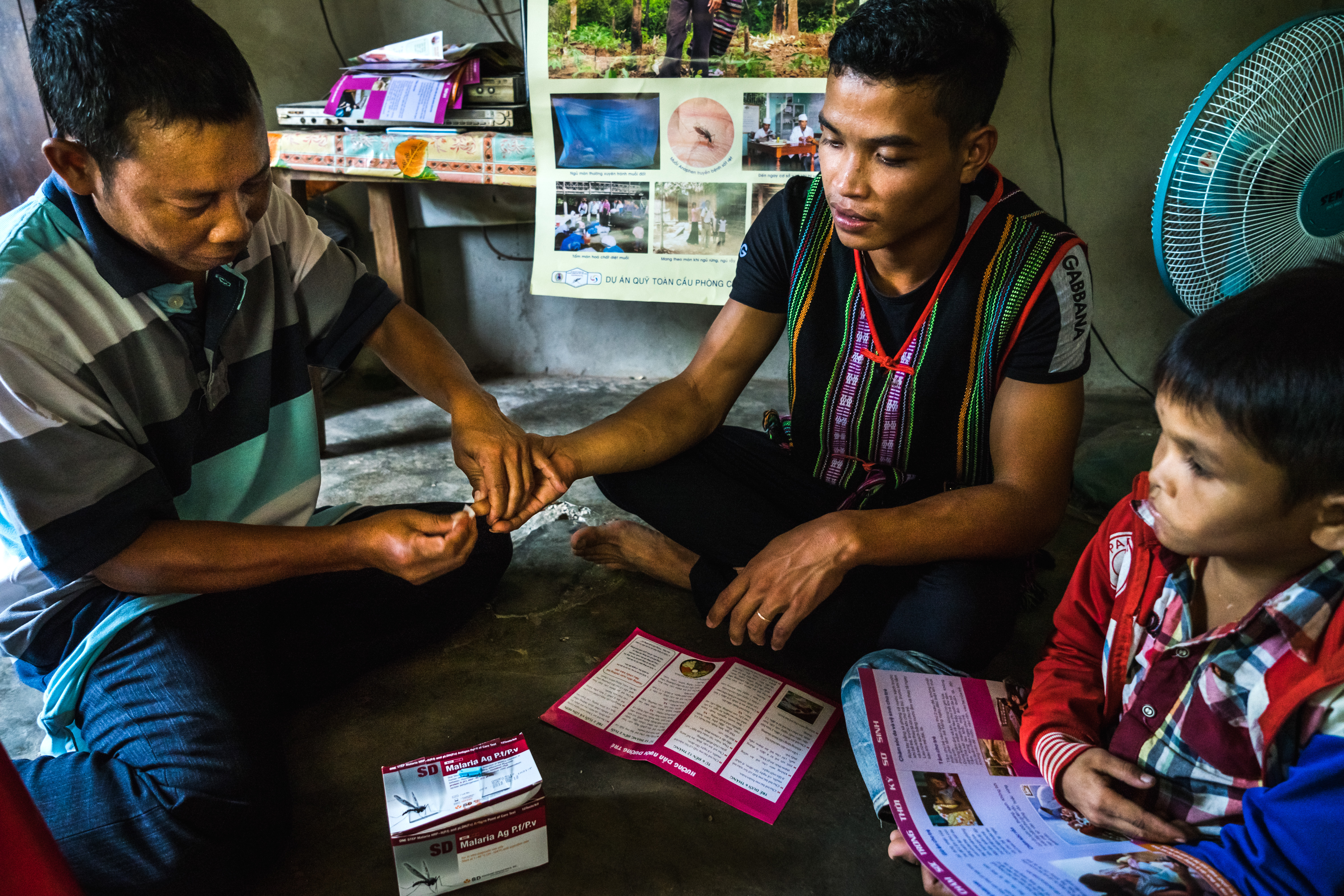
Use cases – SARA field data collection
Survey123 is a suite of tools to conduct geo-located data collection in the field. This tool has been developed by Esri to answer WHO’s needs during the response to the Ebola outbreak in Western Africa (2013-2016).
The questionnaire used for the SARA was integrated in Survey123 and made available to the field data collectors through the tablets sponsored by ADB.
This approach allowed automatic collection of the geographic coordinates of the health facilities being surveyed as well as enabled real-time monitoring of the data collection progress and survey database contents through the online Survey123 dashboard.
More information about Survey123 and how to use it can be found in the Health GeoLab Collaborative Survey123 starter kit .
Result 1 - Malaria monitoring
Connecting the malaria case reporting database from NIMPE to the health facility location database collected by WHO Viet Nam allowed the mapping of the monthly number of positive Malaria cases reported in the health facilities across the five selected Provinces over 2017.
This information has been used to generate an animation (shown on the right for 4 of those 5 Provinces) that shows the monthly evolution of these number of cases per district over that particular year.
The establishment of a common geo-registry for the simultaneous hosting, management, regular update, and sharing of the master lists for the geographic objects core to public health (health facilities, administrative divisions, and villages) would not only facilitate the creation of such type of animation to support real-time disease monitoring and surveillance but also the use of more advanced analytical and modelling capabilities offered by GIS software.
Result 2 - SARA
The SARA covered 112 health facilities distributed over 14 districts in 5 different provinces (4 of them presented in the map on the right).
Data for SARA indicators can be mapped on top of other statistics such as prevalence or incidence data (click on the map to get the figures attached to each district or health facility).
For example, the map on the right allows to visualize the capacity that the surveyed health facilities have to conduct malaria rapid diagnostic testing (RDT) and microscopy on top of the total number of positive cases observed at the district level in 2017.
This kind of thematic map represents a powerful visualization tool to inform decision makers on where capacities could be lacking to answer the demand for malaria-related services.
Summary
The support provided until now by ADB resulted in:
- The strengthening of NIMPE’s technical capacity to manage and use geospatial data and technologies
- The definition of data specifications and the identification of protocols supporting good geospatial data management practices
- The provision of equipment and appropriate geospatial technology to collect and visualize data on a map
- The illustration of the benefits provided by such capacity through two first use cases
All of the above supports NIMPE in the implementation of Circular 54.
Way forward
For NIMPE to:
- Sustain and expand the technical capacity that has been estabished
- Properly integrate the geographic and time dimensions in the new Malaria Information System to allow for the mapping of any information/data it manages.
For the MOH to:
- Support the establishment of the other elements of the HIS geo-enabling framework, including the development, maintenance, regular update, and sharing of the master lists and associated geographies (figure on the right), and this to support not only NIMPE’s needs but also the needs of the other programs such as GDPM, VAMS, DPF, and EHA.


