
Patapsco Regional Greenway | Guinness to Southwest Area Park
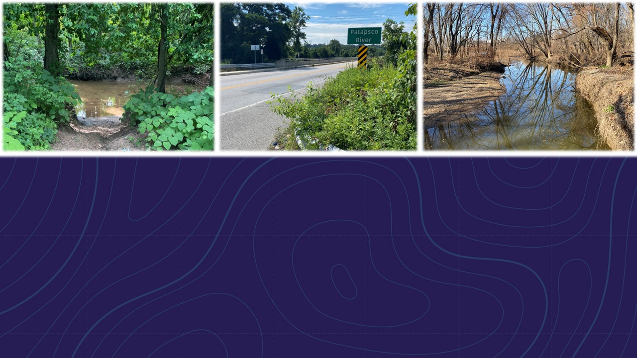
The Patapsco Regional Greenway
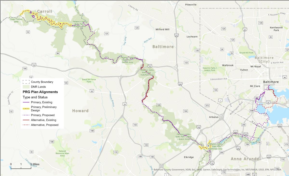
The vision for a continuous 40-mile trail from the treasured Inner Harbor to historic downtown Sykesville is captured in the 2017 Patapsco Regional Greenway (PRG) Plan. The Baltimore Regional Transportation Board (BRTB) approved this planning document which is now spurring future feasibility studies, funding, design and implementation. In addition to becoming a valuable regional trail for recreation and transportation, the Patapsco Regional Greenway will connect communities, promote economic development, advance active transportation options and improve community health.
Preliminary design was completed for two of the PRG segments, highlighted in the map.
Guinness to Southwest Area Park
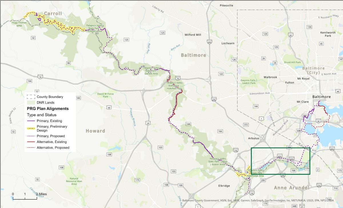
The 2017 PRG Plan includes a conceptual alignment between the Guinness Open Gate Brewery (Guinness) and the Southwest Area Park, traversing Patapsco Valley State Park, in Baltimore County. The box in the lower right corner of this map shows this section of the Patapsco Regional Greenway as identified in the PRG Plan.
BMCs current effort builds upon the PRG Plan by further reviewing alternative alignments for the Guinness to Southwest area segment of the PRG and developing preliminary design. The trail will connect to two MTA Light Rail Stations, Baltimore Highlands and Patapsco, and to Southwest Area Park. The trail will create a bicycle and pedestrian facility to connect the neighborhood to the natural environment and provide a transportation alternative within the region.
Preliminary design was completed for the PRG Elkridge to Guinness segment and final design is currently underway. This segment ties into the PRG Guinness to Southwest Area Park segment.
As a whole, the PRG will draw bikers, hikers, runners, and walkers of all kinds.
The Guinness to Southwest Area Park segment of the PRG will use a variety of facility types to accommodate safe and comfortable use by pedestrians and bicyclists. The facilities being explored include asphalt/concrete pathways, crushed compacted stone pathways and bicycle boulevards.
Alternative Alignments
Through extensive field investigation, environmental consideration and diligent project team coordination, four trail alternatives have been identified for the Guinness to Southwest Area Park segment. These are the Lansdowne, Patapsco River, Halethorpe and Baltimore Highlands Alternatives.
The Guinness to Southwest Area Park segment may require multiple facility and surface types. However, all four alternatives will consist of facilities that can be used by pedestrians and bicyclists. The path from Guinness Open Gate Brewery to Annapolis Road and from Southwest Area Park to the Patapsco Light Rail Station will be a path with a hard surface (asphalt/concrete) or a compacted crushed stone surface. Hard surface trails are preferred for this section of the PRG to promote transportation use; however, compacted crushed stone may be required for trail alignments within DNR property. Conversations and coordination with project partners and stakeholders are ongoing. The path segment between Annapolis Road and Georgia Avenue will be an asphalt or concrete shared use path (a path alongside but separated from the roadway). While the Georgia Avenue section will include a 5-foot-wide sidewalk for pedestrians and on road shared lane markings for bicyclists and scooter users.
The final design of the preferred alternative will include the design of pedestrian and bicycle safety enhancements, such as pedestrian bridges over tributaries, pedestrian and bicycle crossing treatments, crosswalks and more.
Lansdowne Alternative
The approximately 5.5-mile Lansdowne Alternative alignment would primarily follow the existing BGE maintenance path/utility corridor.
01 / 11
1
The proposed 10-foot-wide trail would extend from the Guinness Open Gate Brewery beneath the MARC train bridge over the Patapsco River and continue along the BGE maintenance path towards the stream, Herbert Run.
2
A bridge would be required to cross Herbert Run and continue the alignment along the BGE maintenance road.
3
This alignment includes a proposed connection from the BGE maintenance path to Halethorpe Farms Road which could provide an access point for the trail users.
4
The trail alignment would continue east along the BGE maintenance path, crossing Transway Road at the entrance of Cockey’s Enterprises, and providing another trail access point. High visibility pedestrian crossing features, such as rectangular rapid flashing beacons, will be considered at the Transway Road crossing location to ensure adequate safety.
5
The proposed alignment would continue east around the Cockey’s Enterprises property and beneath the I-695 overpass.
6
The trail alignment would turn northeast along the BGE maintenance path running adjacent to an unnamed tributary of the Patapsco River and then would cross this tributary within the utility corridor using a proposed pedestrian bridge structure.
The trail then extends out to Hammonds Ferry Road where a pedestrian crossing will be needed. High visibility crossing features and user refuge island treatments will be considered to ensure adequate trail crossing safety at Hammonds Ferry Road, which is a two-lane roadway with a 30 MPH speed limit.
7
The trail would continue east of Hammonds Ferry Road along the existing BGE maintenance path and transition south below the MD-295 overpass.
8
The trail would continue along the south edge of the utility corridor past National Tank & Equipment avoiding conflict with the heavy truck traffic along the business entrance road, before connecting to Annapolis Road.
9
At this point, the trail would continue north along the west side of Annapolis Road towards Baltimore Highlands Elementary School using a 10-foot-wide shared-use path with a 5-foot-wide grass buffer. The shared-use path would likely be an asphalt material. The existing wide travel lane widths along Annapolis Road will be reduced to standard widths to accommodate the shared-use path and buffer space. The speed limit along Annapolis Road is 30 miles per hour.
10
The alignment would then use Georgia Avenue to connect the path with the MTA Baltimore Highlands Light Rail Station and the Southwest Area Park. Georgia Avenue is a residential roadway with on-street parking on both sides and no marked speed limit. A five-foot-wide sidewalk would be used to accommodate pedestrians on the south side and shared-lane pavement markings would allow bicycles to share the travel lanes with vehicles without impacting existing on-street parking.
11
The alignment would rejoin the BGE utility corridor to travel north and would transition back to a ten-foot-wide greenway. The path would travel along the western edge of Southwest Area Park from the Baltimore Highlands Light Rail Station to the MTA Patapsco Light Rail Station. Along this corridor, several connections to the Southwest Area Park entrances and existing parking lots could provide access points to the park amenities.
Patapsco River Alternative
The approximately 6-mile Patapsco River Alternative would primarily run through large sections of wooded landscape parallel to the Patapsco River providing glimpses of the river through the vegetation as the path connects Guinness Open Gate Brewery and Southwest Area Park/Patapsco Light Rail Station.
01 / 10
1
The proposed 10-foot-wide trail would extend from the Guinness Open Gate Brewery beneath the MARC train bridge over the Patapsco River and continue parallel to the Patapsco River towards the Herbert Run stream.
2
A pedestrian bridge would be required to cross Herbert Run and continue the alignment along the river.
3
The trail alignment would continue east alongside the Patapsco River within DNR property. The path would then cross two unnamed tributaries of the Patapsco River which will require proposed pedestrian bridge structures, one to the south of Halethorpe Farms Road and one to the southwest of Cockey’s Enterprises.
4
The proposed alignment would continue along the Patapsco River and use the BGE maintenance path to cross beneath the I-695 overpass.
5
The alignment travels southeast toward the Patapsco River and immediately crosses another unnamed tributary of the river with a proposed pedestrian bridge structure. The path would follow the Patapsco River through a wooded area and cross Hammonds Ferry Road. High visibility crossing features and user refuge island treatments will be considered to ensure adequate trail crossing safety at Hammonds Ferry Road, which is a two-lane roadway with a 30 MPH speed limit.
6
Between Hammonds Ferry Road and Annapolis Road, the trail would parallel the river traveling within DNR and Baltimore County properties. The trail would travel beneath the MD-295 overpass.
7
The trail would continue east along the Patapsco River until the path intersects with Annapolis Road approximately 80 feet north of the bridge over the Patapsco River.
8
At this point, the trail would continue north along the west side of Annapolis Road towards Baltimore Highlands Elementary School using a 10-foot-wide shared-use path with a 5-foot-wide grass buffer. The shared-use path would likely be an asphalt material. The existing wide travel lane widths along Annapolis Road will be reduced to standard widths to accommodate the shared-use path and buffer space. The speed limit along Annapolis Road is 30 miles per hour.
9
From this location to the Patapsco Light Rail Station, this alternative would follow the same route as the other three alignments. The Patapsco River Alternative alignment would use Georgia Avenue to connect the path with the MTA Baltimore Highlands Light Rail Station and Southwest Area Park. Georgia Avenue is a residential roadway with on-street parking on both sides and no marked speed limit. A five-foot-wide sidewalk would be used to accommodate pedestrians on the south side and shared-lane pavement markings would allow bicycles to share the travel lanes with vehicles without impacting existing on-street parking.
10
The alignment would join the BGE utility corridor to travel north and would transition back to a ten-foot-wide greenway. The corridor travels along Southwest Area Park from the Baltimore Highlands Light Rail Station to the MTA Patapsco Light Rail Station. Along this corridor, several connections to the Southwest Area Park entrances and existing parking lots could provide access points the park amenities.
Halethorpe Alternative
The Halethorpe Alternative would provide an approximately 5.5-mile greenway connection between Guinness Open Gate Brewery and Southwest Area Park/Patapsco Light Rail Station. This alternative would be a combination of the proposed Lansdowne and Patapsco River Alternatives. For the portion between Guinness Open Gate Brewery and I-695, this alignment would follow the BGE utility corridor along the north edge of the project study area.
01 / 11
1
The proposed 10-foot-wide trail would extend from the Guinness Open Gate Brewery beneath the MARC train bridge over the Patapsco River and continue along the BGE maintenance path towards the Herbert Run stream.
2
A bridge would be required to cross Herbert Run and continue the alignment along the BGE maintenance road.
3
This alignment includes a proposed connection from the BGE maintenance path to Halethorpe Farms Road which could provide an access point for the trail users.
4
The trail alignment would continue east along the BGE maintenance path, crossing Transway Road at the entrance of Cockey’s Enterprises, and providing another trail access point. High visibility pedestrian crossing features, such as rectangular rapid flashing beacons, will be considered at the Transway Road crossing location to ensure adequate safety.
5
The proposed alignment would continue east around the Cockey’s Enterprises property and beneath the I-695 overpass.
6
East of I-695, this alignment would follow the Patapsco River Alternative alignment immediately crossing another unnamed tributary of the Patapsco River using a proposed pedestrian bridge structure.
The path would follow the Patapsco River through a wooded area and cross Hammonds Ferry Road. High visibility crossing features and user refuge island treatments will be considered to ensure adequate trail crossing safety at Hammonds Ferry Road, which is a two-lane roadway with a 30 MPH speed limit.
7
Between Hammonds Ferry Road and Annapolis Road, the trail would parallel the river traveling within DNR and Baltimore County properties. The trail would travel beneath the MD-295 overpass.
8
The trail would continue east along the Patapsco River until the path intersects with Annapolis Road approximately 80 feet north of the bridge over the Patapsco River.
9
At this point, the trail would continue north along the west side of Annapolis Road towards Baltimore Highlands Elementary School using a 10-foot-wide shared-use path with a 5-foot-wide grass buffer. The shared-use path would likely be an asphalt material. The existing wide travel lane widths along Annapolis Road will be reduced to standard widths to accommodate the shared-use path and buffer space. The speed limit along Annapolis Road is 30 miles per hour.
10
Like the other alternatives, the alignment would use Georgia Avenue to connect the path with the MTA Baltimore Highlands Light Rail Station and the Southwest Area Park. Georgia Avenue is a residential roadway with on-street parking on both sides and no marked speed limit. A five-foot-wide sidewalk would be used to accommodate pedestrians on the south side and shared-lane pavement markings would allow bicycles to share the travel lanes with vehicles without impacting existing on-street parking.
11
The alignment would rejoin the BGE utility corridor to travel north and would transition back to a ten-foot-wide greenway. The path would travel along the western edge of Southwest Area Park from the Baltimore Highlands Light Rail Station to the MTA Patapsco Light Rail Station. Along this corridor, several connections to the Southwest Area Park entrances and existing parking lots could provide access points the park amenities.
Baltimore Highlands Alternative
The Baltimore Highlands Alternative would provide an approximately 6-mile greenway between Guinness Open Gate Brewery and the Southwest Area Park. This alternative would be a combination of the proposed Patapsco River and Lansdowne Alternatives. For the portion between Guinness and I-695, this alternative would use the existing path within DNR lands parallel to the Patapsco River. Similar to the Patapsco River Alternative, it would provide large sections of wooded landscape throughout the trail segment with scattered views of the Patapsco River.
01 / 10
1
The proposed 10-foot-wide trail would extend from the Guinness Open Gate Brewery beneath the MARC train bridge over the Patapsco River and continue parallel to the Patapsco River towards the Herbert Run stream.
2
A bridge would be required to cross Herbert Run and continue the alignment along the river.
3
The main path of this alignment would continue east alongside the Patapsco River within DNR property. The path would then cross two unnamed tributaries of the Patapsco River which will require proposed pedestrian bridge structures, one to the south of Halethorpe Farms Road and one to the southwest of Cockey’s Enterprises.
4
The proposed alignment would continue along the Patapsco River and use the BGE maintenance path to cross beneath the I-695 overpass.
5
The trail alignment would then turn northeast along the BGE maintenance path running adjacent to an unnamed tributary of the Patapsco River and then would cross this tributary within the utility corridor using a proposed pedestrian bridge structure.
The trail then extends out to Hammonds Ferry Road where a pedestrian crossing will be needed. High visibility crossing features and user refuge island treatments will be considered to ensure adequate trail crossing safety at Hammonds Ferry Road, which is a two-lane roadway with a 30 MPH speed limit.
6
The trail would continue east of Hammonds Ferry Road along the existing BGE maintenance path and transition south below the MD-295 overpass.
7
The trail would continue along the south edge of the utility corridor past National Tank & Equipment avoiding conflict with the heavy truck traffic along the business entrance road, before connecting to Annapolis Road.
8
At this point, the trail would continue north along the west side of Annapolis Road towards Baltimore Highlands Elementary School using a 10-foot-wide shared-use path with a 5-foot-wide grass buffer. The shared-use path would likely be an asphalt material. The existing wide travel lane widths along Annapolis Road will be reduced to standard widths to accommodate the shared-use path and buffer space. The speed limit along Annapolis Road is 30 miles per hour.
9
There, like the preceding alternatives, the alignment would use Georgia Avenue to connect the path with the MTA Baltimore Highlands Light Rail Station and the Southwest Area Park. Georgia Avenue is a residential roadway with on-street parking on both sides and no marked speed limit. A five-foot-wide sidewalk would be used to accommodate pedestrians on the south side and shared-lane pavement markings would allow bicycles to share the travel lanes with vehicles without impacting existing on-street parking.
10
The alignment would rejoin the BGE utility corridor to travel north and would transition back to a ten-foot-wide greenway. The path would travel along the western edge of Southwest Area Park from the Baltimore Highlands Light Rail Station to the MTA Patapsco Light Rail Station. Along this corridor, several connections to the Southwest Area Park entrances and existing parking lots could provide access points the park amenities.
Proposed Concepts
Along the BGE Maintenance Road
The rendering shows the proposed shared-use path compared to the existing conditions of the northern alignments along the BGE maintenance road. The trail surface along the BGE maintenance road will be a hard asphalt or concrete surface material to allow for BGE maintenance vehicles to access the path when needed.
Along the Patapsco River
The rendering shows the proposed shared-use path compared to the existing conditions of the southern alignments along the Patapsco River. Although a hard surface trail material is shown here, the trail surface type along the Patapsco River may need to be crushed compacted stone or a boardwalk due to proximity to the floodplain.
Annapolis Road
The rendering shows the proposed shared-use path compared to the existing conditions along Annapolis Road under the I-895 overpass, looking south. The trail will be a 10-foot-wide shared-use path with a 5-foot-wide grass buffer along the west side of Annapolis Road.
Tradeoffs
Considering the alternatives requires weighing the benefits and tradeoffs of each alignment. The matrix below highlights some of the most significant factors.
Guided Tour
A guided photo tour is included below which provides an "on-the-ground" view of existing conditions in the study area. The tour follows the BGE Utility Corridor, the Patapsco River, Annapolis Road and Georgia Avenue.
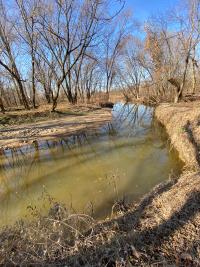
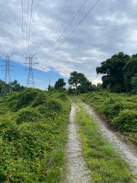
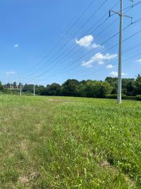
Herbert Run

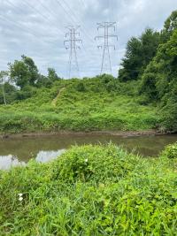
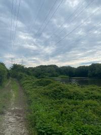
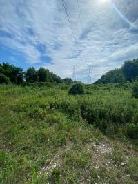
BGE Utility Corridor
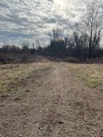
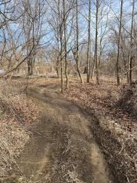
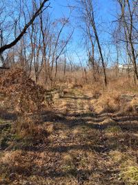
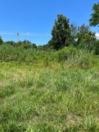
Worn Path into Patapsco Valley State Park
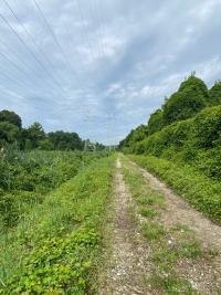
BGE Utility Corridor
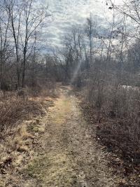
Worn Path Along Patapsco River
Wetlands Adjacent to Corridor
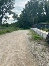
I-895 Overpass
Worn Path Along Patapsco River
BGE Utility Corridor
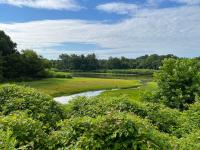
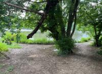
Lake
Natural Look-out Area
Worn Path Along Patapsco River
BGE Utility Corridor and Lake
Patapsco River Tributary
BGE Utility Corridor
Approaching Transway Road/Cockey's Enterprises
Transway Road/Cockey's Enterprises Driveway Crossing
Grassy Area Between I-895 and Cockey's Enterprises
Worn Path Along Patapsco River
BGE Utility Corridor Abutting Cockey's Enterprises
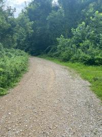
BGE Utility Corridor
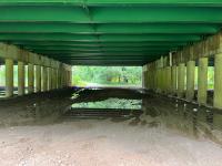
Under I-695 Bridge
BGE Utility Corridor
Stream Crossing the BGE Corridor
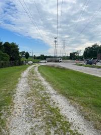
Hammonds Ferry Road

Hammonds Ferry Road
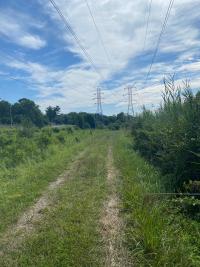
BGE Utility Corridor

Natural Surface Path Along River
MD 295 Overpass
BGE Utility Corridor
Natural Surface Path Along River
Annapolis Road
Annapolis Road and I-895 Overpass

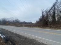
Yarnall Road and Annapolis Road Intersection
Virginia Avenue and Annapolis Road Intersection
Baltimore Highlands Elementary School
Georgia Avenue and Annapolis Road
Georgia Avenue
Baltimore Highlands Light Rail Station
Southwest Area Park
Baltimore Highlands Light Rail Station
BGE Utility Corridor Along Southwest Area Park
Patapsco Light Rail Station
Patapsco Light Rail Station
Herbert Run
Herbert Run, a tributary of the Patapsco River, will require a bridge to cross.
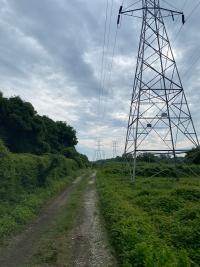
BGE Utility Corridor
Existing BGE maintenance road with photo facing west.
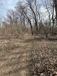
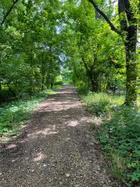
Worn Path into Patapsco Valley State Park
A worn path diverges from the BGE utility corridor into the Patapsco Valley State Park.
BGE Utility Corridor
Worn Path Along Patapsco River
Wetlands Adjacent to Corridor
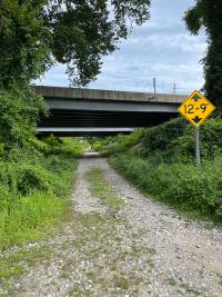
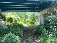
I-895 Overpass
The BGE maintenance road travels under the I-895 overpass to connect to Halethorpe Farms Road. Photo looking north.
Worn Path Along Patapsco River
BGE Utility Corridor
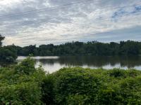
Lake
Lake with wetlands south of the BGE utility corridor. Photo looking south.
Natural Look-out Area
Worn Path Along Patapsco River
BGE Utility Corridor and Lake
Patapsco River Tributary
A tributary of the Patapsco River that is wide enough to require a bridge to cross.
BGE Utility Corridor
Approaching Transway Road/Cockey's Enterprises
Transway Road/Cockey's Enterprises Driveway Crossing
There are no marked crosswalks or intersections with traffic signals which aid pedestrian crossing Transway Road/Cockey’s Enterprises driveway in this area next to I-895.
Grassy Area Between I-895 and Cockey's Enterprises
Grassy area fenced off from Transway Road and Cockey's Enterprises.
Worn Path Along Patapsco River
The natural surface or unpaved worn path runs along the Patapsco River behind Cockey's Enterprises.
BGE Utility Corridor Abutting Cockey's Enterprises
The BGE utility corridor continues east of Cockey's Enterprises.
BGE Utility Corridor
Under I-695 Bridge
The BGE maintenance road travels under the I-695 overpass. Photo looking west.
BGE Utility Corridor
Stream Crossing the BGE Corridor
Stream, surrounded by vegetation.
Hammonds Ferry Road
There are no marked or signalized pedestrian crossings in this area of Hammonds Ferry Road.
Hammonds Ferry Road
There are no marked or signalized pedestrian crossings in this area of Hammonds Ferry Road.
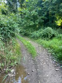
BGE Utility Corridor
Natural Surface Path Along River
Natural surface or unpaved path follows the Patapsco River.
MD 295 Overpass
The BGE maintenance road travels under the MD 295 overpass. Photo looking west.
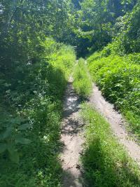
BGE Utility Corridor
Natural Surface Path Along River
Natural surface or unpaved path follows the Patapsco River.
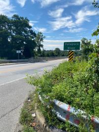
Annapolis Road
Natural surface or unpaved path ends at gate and intersects with Annapolis Road.
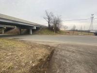
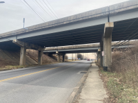
Annapolis Road and I-895 Overpass
Annapolis Road has a sidewalk on the western side of the road from Manoff Road to Yarnall Road. Annapolis Road travels under the I-895 overpass. Photo looking south.
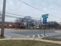
Yarnall Road and Annapolis Road Intersection
A sidewalk is on both sides of Annapolis Road from Yarnall Road to Georgia Avenue.
Virginia Avenue and Annapolis Road Intersection
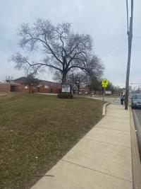
Baltimore Highlands Elementary School
The elementary school is located on Annapolis Road near Georgia Avenue.
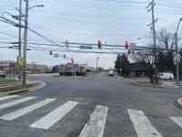
Georgia Avenue and Annapolis Road
The intersection has crosswalk markings on three legs of the intersection but does not have traffic or pedestrian signals.
Georgia Avenue
Local street with a 25 mph speed limit, two-way travel, on street parking and intermittent sidewalks.
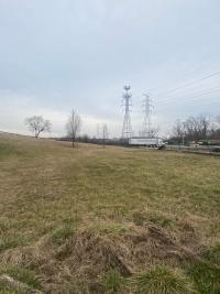
Baltimore Highlands Light Rail Station
MTA light rail station and connection to Klunk Drive/Southwest Area Park.
Southwest Area Park
Entrance to Southwest Area Park.
Baltimore Highlands Light Rail Station
Pedestrian crossing location to the Baltimore Highlands Light Rail Station.
BGE Utility Corridor Along Southwest Area Park
Patapsco Light Rail Station
The elevation changes of the Patapsco Light Rail Station is considerably higher than the elevation of the BGE maintenance road. View from BGE maintenance road.
Patapsco Light Rail Station
The elevation changes of the Patapsco Light Rail Station is considerably higher than the elevation of the BGE maintenance road. View from Patapsco Light Rail Station.
Comments
Your feedback is important to us! Now that you've been introduced to each of the four alternatives to connect the Guinness Open Brewery to Southwest Area Park, please take a moment to answer the following questions.
PRG | Guinness to Southwest Area Park Comment Survey
Tell Us More
Do you have specific concerns about any of the alternatives? Are there particular areas or points of interest that you would like the project team to consider? Let us know by placing the appropriate icon and providing comment on the map below!


