Cinematic Captures in the Mountains: Filming Cars with UAS
A story about a trip to the Chilhowee Mountains and all the challenges and products that came with it.
The landscape of the Appalachian Mountains don't come all at once. Traveling down from Purdue University, the flat green farm fields and pastures slowly morphed into a series of small pockets of hillsides, and eventually, into an endless sprawling of expansive peaks and long winding valleys. The mist and dew of the morning would nestle into cool and damp defilades and eventually would burn off from the heat of the Sun by noon.
My goal for this trip started much differently than how it ended. Having a trifold passion for drone cinematography, cars, and scenic views seemed only to enhance the motivation and inspiration for this. This story map is not only to share content created from the trip, but to explain the evolution and continuous changes that resulted in a final set of deliverables.
Introduction to Project and Flight Area
Though representing flight skills and cinematic passion by using UAS products was a key takeaway for this project, so much of its fruition relied on the simplistic beauty and aesthetic of the flight area. This process was somewhat of a lengthy one that went through a series of iterations to finally end up with a final selection. Let's take a look.
Figure 1: Initial Perspective Area of Operations with LAANC Airspace
Pictures above is where I wanted to have the initial flight area. This is an interactive map with FAA LAANC Airspace areas also present. The highlighted path was what I envisioned the vehicle to be traveling on, with the red marker being the takeoff position and the blue being the landing position. The main rationale for choosing this area was for two reasons: it was largely open which would help maintain visual line of sight (VLOS) and was relatively straight and accessible by vehicle. This strip of road is called the Calderwood Highway and though both two traits ring true, its scenic appeal was lackluster compared to other sites nearby.
The greater surrounding area, though new to me, was certain to have much more cinematic and appealing footage to be found. So, the search continued on.
Knowing not only the scenic capabilities of the area to be abundant but also popular, the decision had to be made regarding the possibility of flying over others not participating in UAS activities. The enthusiasm for the area does not only apply for those who are avid hikers and outdoors people, but also automotive fans. South of Calderwood Highway lies the famous and exhilarating "Tail of the Dragon".
Figure 2: The Infamous "Tail of The Dragon" Highlighted
The length of the Tail of the Dragon is often debated, however, the experience it offers is never contested. Roughly 11 to 13 miles in length, this road presents drivers with close to 320 turns. The road begins just north of the Tennessee border and ends just south of the North Carolina border. Over the years it has become a destination for car enthusiasts and adrenaline junkies to test their driving capabilities.
Figure 3: Picture of the "subject" a 2014 BMW F10 535xi on the Tail of the Dragon
The Tail of the Dragon does offer great cinematic photography, however, the terrain, turns, excessive car presence, and state border proximity all make it challenging to fly with an sUAS regardless of Part 107 or not. Due to these factors, the Tail of the Dragon was also ruled out. With limited opportunities to travel to the flight area, the decision of where to film was going to be decided by in-person scouting within the flight area.
Upon arriving on location, my friend, host, and driver of the F10 535xi informed me that there was a great place to gather some footage. Time was of the essence as I only came equipped with limited time and batteries. Nonetheless, after scouting the decision to move north and west to a ridge top called Chilhowee Mountain was chosen.
Below I have attached a map of which has my flightpath and each main "lookout area" as well.
Figure 4: Final area of operation and further analysis of the terrain using USGS 3D EP
The Chilhowee Mountain is quite meek when compared to the surrounding areas, which include the Unicoi Mountains, the Blue Ridge Mountains, and the Great Smoky Mountains. Though smaller than these famous ranges, Chilhowee offers tall enough elevation and a clean-cut ridge line which allows for open sites and smooth driving.
To emphasize the terrain within the realm of the geospatial effects, I utilized the expansive and detailed databases that the United States Geological Survey (USGS) has. The best to demonstrate terrain values was to use both the 3D Elevation Program (EP) and ArcGIS' Hillshade tool. That way it can be conveyed both with shading and color variance.
Figure 5: Differential view of the terrain features of Chilhowee Mountain
To get a better understanding of the relative height above the surrounding valleys that Chilhowee Mountain presents I have added an image taken directly from ArcGIS to show a more skyline view of the flight area.
Within view of the Chilhowee Mountain ridge is Hannah Mountain, a range that provides phenomenal b-roll and backdrop for footage.
Figure 6: Hannah Mountain is viewable from Chilhowee Mountain
I captured this with the Mavic 2 Pro. I will delve more into the procedures and changes made during the footage collection of this project. However, being blown away by the natural beauty surrounding me, a good deal of emphasis was made simply gathering b-roll and other scenic shots with the Mavic.
Flight Procedures and a Change of Cinematic Direction
Upon brainstorming and researching scientific articles for this endeavor, I initially wanted to conduct a largely scientific research project using a series of tested variables and controls. My controls would be to keep constant vehicle speed, thus UAS, speed as long as lateral distance from the vehicle. My variables, on the other hand seemed a little more complex in execution and nature: differing aerial cinematic captures and different altitudes of which I would fly them at. I would conduct a series of shots: panning shots, tracking shots, and dolly zooms at 50, 150, 250 feet respectively.
Figure 7: Example of some flight maneuvers.
Though the goal was to test and compare in a holistic review, which flight parameters being tested were the most visually appealing and easy to fly for a recreational UAS fans, the view shifted. I instead wanted to focus on quality footage that objectively looked good for viewers regardless of testing variables and maintaining controls in the name of the scientific process.
Figure 7: Some images taken at Look Rock, a look-out area along Chilhowee Mountain
It's not to say that I did not use any flight maneuvers I wanted to initially test. I did a variety of rear and frontal tracking shots as long as panning shots as well. However, I realized that even if quantity of footage lacked, quality could be found. Editing was going to have to be used and learned largely on my end.
The Mavic 2 Pro: Reasoning and Shortcomings
It is not controversial to say that the Mavic 2 Pro is a little long in the tooth. First released to the market in 2018, DJI already has a Mavic 3 Pro model out and plans to drop the 4 soon. However, I chose the Mavic 2 Pro for a few reasons. First, I am most comfortable with the model and have built quite a lot of flight time on it. Second, it is both accessible and transportable. Third, it seems to be a model that is common amongst drone and car hobbyists in general.
Figure 8: Mavic 2 Pro
That being said, the Mavic does not come without its limitations. Primarily, the retained storage for both video and imagery were quite small. I immediately realized that with a diminished ability to upload footage and make room, I only had roughly 3 to 4 minutes of total footage I could capture in one outing. Furthermore, the quality and stability of the Mavic 2 Pro were definitely left to be desired. Shakey footage, even when filming in P-mode often resulted in scapped footage. However, noting this, personal editing decisions and artistic preferences are no-doubt to be held into question as well.
Deliverables and Footage
My two main deliverables I wanted to make sure were collected was both cinematic footage and imagery. However, included within this was also a ArcGIS Animated Fly-Through feature. I wanted to have this as an additional deliverable as it not only made sure that geospatial analysis was done within consideration to the project but also to help the viewer get a 3D visual aid to the flight area.
Figure 9: Interactive Flight Path Scene (3D)
Above is an online map created that viewers can use to navigate, in three dimensions, the flight area flown along with each lookout along the way. Lookouts were used primarily for B-roll footage and also for stationary shots of the car.
Figure 10: ArcGIS Animated Fly-Through: Chilhowee Mountain (Foothills Parkway Hwy)
Above is a video of the Fly-Through posted to my Youtube channel. I tried to stop at each look out point, while also making sure the video was short enough as not to draw it out too long. Furthermore, below this text there is a video containing my footage and editing of the flights. To me, the final product is no where near perfect and never will be. One such regret I have about the creation of the video is that I think I omitted too much footage. Nonetheless, my pickiness and continuous editing may have shortened the video too much. However, I am content with all the other work I put in and I hope you enjoy, thanks.
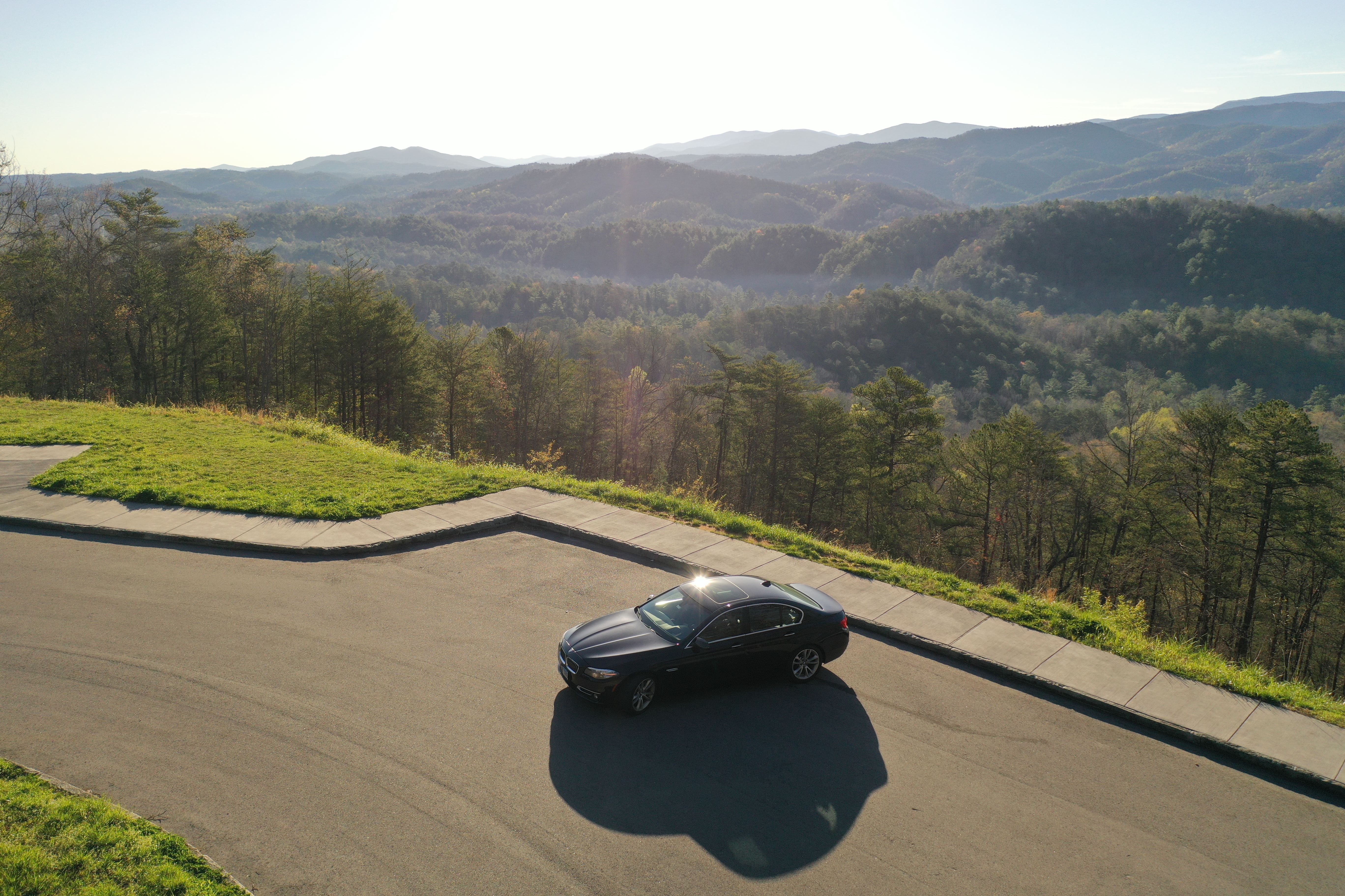
Figure 11: Cinematic Capture of BMW in Chilhowee Mountains
Conclusions and Acknowledgements
In conclusion, this project was indeed a fun and informative in general. It was a unqiue experience to use skills learned over the past years and apply it to study that I find both interesting and exciting. Using both flight and ArcGIS nuanced techniques to create final deliverables really sums up the entirety of my time spent at Purdue University and will hopefully help foster a continued future within the industry. I would like to thank Purdue University, the Unmanned Aerial Systems (UAS) major, and both Professor J. Hupy and D. Lercel for the learning environment they created.


