Drone2Map for Water Utilities
Reimagining Operations for Water Utilities
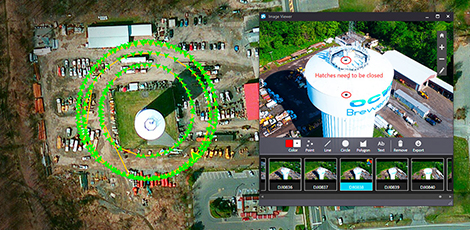
Water utilities are leveraging Drone2Map for ArcGIS. It allows you to streamline the creation of professional imagery products from drone-captured still imagery for visualization and analysis in ArcGIS.

With Drone2Map for ArcGIS, you can:
- Safeguard your people and organization from injuries. High water towers, rural terrain, and compromised infrastructure can be inspected with preprogrammed flight paths while field staff are safe on solid ground.
- Monitor assets in record time, and bring productivity to new heights. Water tank inspections and model creation—once very time-consuming using traditional methods—can now be completed at low cost with speed, precision, and collaboration.
- Unlock a Unique Perspective. 3D imagery allows you to look for physical damage and corrosion and assess overall conditions to help you make timelier and better decisions. We live in a 3D world, and it's time to analyze, inspect, and visualize it in 3D.
Get Advice from an Expert
Get your questions answered on how Drone2Map works across the ArcGIS Platform.