It’s time to refresh your browser – ArcGIS Online has been updated with the following new features and enhancements. This update includes new features and capabilities for authoring web maps, app templates, managing and administering organizations, and more.
Map viewer enhancements
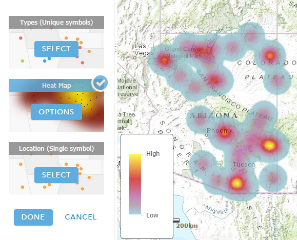
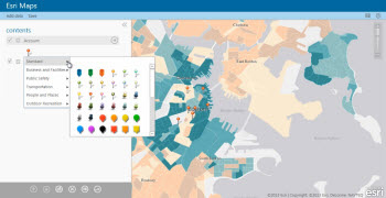
Data-driven “smart mapping”
The map viewer now includes data-driven workflows that enable you to author visually appealing web maps easily. When feature layers are added, the data is analyzed and appropriate layer styling options are presented in a streamlined user experience. Capabilities include creating heat maps, continuous color ramps, using size and transparency, and graduated symbols. See Change style for more information.
Other map viewer enhancements include:
- Image layers with vector fields can now display the magnitude and direction of variables as vectors using a new multidimensional filter. The symbol style can also be changed.
- Route directions are now supported for up to 50 stops.
- A new points of interest symbol set has been added, and the shapes symbol set becomes the default. The A to Z symbol set now includes AA to ZZ.
Scene Viewer
The scene viewer is one of the built-in ArcGIS Online apps, complementing the map viewer by enabling you to author, view, and share 3D scenes. The scene viewer (introduced in December 2014) is no longer in beta and is officially released. New features and capabilities have also been added.
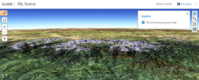
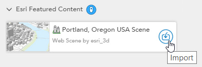
Esri featured web scenes showcase 3D views from around the world. Using featured web scenes you can import multiple scenes into your own scene and make changes. See Add Esri featured web scenes.
With this release you can also modify and save copies of scenes that you do not own, can create legends for your scenes, and can adjust layer transparency.
Story Maps
Story maps combine interactive maps and multimedia content into elegant user experiences, making it easy to use maps to tell stories. View examples at the Story Maps Gallery.
Story Map Series released
Story Map Series is no longer in beta, and is officially released. Story Map Series offers several different layout options — tabbed, side accordion, and bulleted — making it ideal for presenting multiple maps.

Web accessibility
Story Map Journal, Story Map Tour, and Story Map Series have improved accessibility features, including optimization for screen readers and for keyboard navigation. The Tab key becomes the primary method for keyboard navigation, in compliance with U.S. Section 508 accessibility standards.
Story Map Series has also been added to the Configurable Apps gallery, see details below.
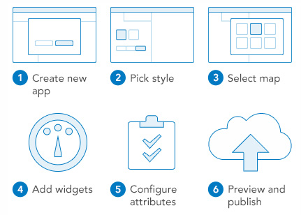
App Templates
App templates offer an easy way to create custom-configured applications, with no programming required. Author a web map, choose a template from the gallery, then publish, configure, and save.
Configurable Apps gallery includes the following new templates:
- Story Map Series enables you to present multiple maps using several layout options; tabbed, side accordion, and bulleted. Story Map Series includes a builder app to make authoring easy. See Story Maps apps for more information.
- Compare Analysis allows you to compare up to four maps at once.
- Map Tools allows you to display a map with a specified set of commonly used tools.
The Early Adopter Templates group adds the following:
- Crowdsource Reporter is a responsive gallery app template that allows users to submit observations or feedback. Users can submit new reports, review existing reports, and comment and vote on those submitted by other users.
- Crowdsource Manager complements Crowdsource Reporter enabling users to review, update, and manage submitted observations and feedback.
Enhanced templates
- Edit has been redesigned for better support on devices. It can now be configured to include a basemap toggle widget which allows users to switch to an alternate basemap. It can also be configured to continuously track a user’s location with the press of a button.
- Elevation Profile can now be configured to use a custom elevation profile service.
- Edit, Map Tools, Elevation Profile, Filter, Legend, Simple Map Viewer, and Basic Viewer now allow users to choose from available geocoders or searchable layers within the map when entering a search string.
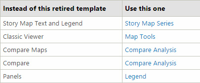
Retired templates
Several app templates have been retired, though existing applications using hosted retired templates will continue to function.
Web AppBuilder for ArcGIS
The Web AppBuilder for ArcGIS enables you to build responsive, cross-device applications without needing to write any code.
The Web AppBuilder includes the following new features and capabilities:
- Support for related records in pop-ups, attribute tables, and query results.
- Support for feature search based on search settings in the map.
- Support for customizing map scales.
- URL parameters can now be used to modify the app.
- New Analysis, Time Slider, and Swipe widgets.
- Layer list now displays table, raster, and image layers.
See Web AppBuilder for ArcGIS for more information.
New community functionality is available at opendata.arcgis.com. Use this website to search across all organizations that have shared their authoritative data via ArcGIS Open Data.

You can also add any items you find via opendata.arcgis.com to your favorites for easy access. For more information see What is ArcGIS Open Data.
Esri Maps for Salesforce
A new integration with Salesforce1 mobile app that enables Salesforce users to find customers near their location, check in at a customer’s site, post to chatter, and enrich Salesforce data with demographic information. Both mobile and web integrations are included with your ArcGIS Online subscription.
The web integration helps Salesforce users create workflows to geocode any Salesforce objects, map and perform spatial analysis on Salesforce data, and share maps and data to ArcGIS. See Esri Maps for Salesforce for more information.
Esri Maps for Office
The upcoming release of Esri Maps for Office will include the following enhancements:
- A new, more visual workflow for adding data helps you understand what type of map you are going to create and how many credits it will consume before you create the map.
- New floating maps allow you to drag maps outside the Excel window and scroll through your Excel data while keeping maps visible.
- Support for all of the coordinate systems supported by the ArcGIS API for Javascript.
- Support for linear feature services as custom location types.
- Support for adding multiple maps and displaying them side by side to compare data from multiple worksheets.
Esri Maps for Office for more information.
Operations Dashboard for ArcGIS
Use the browser app to open publicly available operation views without signing in. For the latest information see Operations Dashboard for ArcGIS.
Organization administration
Data curator role
Custom roles adds a new privilege to facilitate data curation. The privilege allows data curators in your organization to add, delete, and update features in editable hosted feature layers, regardless of the editing options enabled for the layer. For example, curators can manage citizen feedback in an app without needing ownership access to the underlying feature layers.
A new data curator role template is available that encompasses the basic privileges needed for preparing and processing data within your organization. It includes the new privilege to edit with full control. Use the template as it has been configured or further customize it by adding and removing the privileges that fit the needs of your organization.
Enhanced item usage reports
Item details now includes usage over a selected time period and is available to anyone who has access to the item.
For Administrators, additional details are available in the subscription status page about the items in your organization. You can access usage details for any item over a selected time period and access the item details from the usage reports. You can also see an ordered list of the tags used in all of the items returned in the current report, the most frequently viewed items in the organization over the past two weeks, the ten most viewed items in the organization since the day the organization was created, and a summary count of the total number of items in the organization.
Configurable password policy
Organizations can now configure the password policy for members with ArcGIS accounts. Administrators can define password length, complexity, and history requirements that meet the security strategies of the organization.
Other administration enhancements
The subscription status page includes location-allocation reports. Organizations can now configure their own route service for getting directions.
Content
- World Elevation now includes 30-meter data for several regions in North America, South America, and Western Europe.
- Updated elevation data has been added for Africa, and Netherlands has additional community elevation data.
- New detailed demographic data has been added for Spain, Germany, and Australia that can be used for mapping and data enrichment.
Miscellaneous
- When exporting hosted feature layers to feature collections, you can now generalize features for web display.
- Greek is available as a language. Language determines the user interface as well as the way time, date, and numerical values appear.
- Panama is available as a region. Region sets the featured maps on the home page, content in the gallery, and the default extent of new maps in the map viewer.
For more information see What’s New.


Commenting is not enabled for this article.